Once TOPAZ is finished, we will see detais about base and rover data, RTK statistic, interative plots w/ positions and epoch-by-epoch positions in form of CSV or NMEA GGA message.
System parameters
| Parameter | Value |
| Request ID | 1772 |
Next table reminds us who was the base and rover:
Input files | File |
Name | Size | | Rover |
ASIR00ITA_R_20232740000_01D_30S_MO.crx | 5.396 MB (5658613 bytes) |
| Base | M0SE00ITA_R_20232740000_01D_30S_MO.crx |
5.876 MB (6161144 bytes) |
Here we may see detailed information about base and rover files:
General Info | ASIR00ITA_R_20232740000_01D_30S_MO.crx | M0SE00ITA_R_20232740000_01D_30S_MO.crx | | File Size | 5.396 MB (5658613 bytes) | 5.876 MB (6161144 bytes) | | Input decoder | AUTO | AUTO | | Used decoder | RINEX | RINEX | | RINEX version | 3.03
Hatanaka Compressed (CRX) | 3.03
Hatanaka Compressed (CRX) | | Epochs | | Rate | 30 sec | 30 sec | | Total | 2880 | 2880 | | Time issues | 0 (0.000% ) | 0 (0.000% ) | | Missed | 0 (0.000% ) | 0 (0.000% ) | | Duration | 24 hours 0 min | 24 hours 0 min | | Time Start | Date: 2023.10.01
Time: 00:00:0.00
DOY: 274
Week: 2282
| Date: 2023.10.01
Time: 00:00:0.00
DOY: 274
Week: 2282
| | Time Stop | Date: 2023.10.01
Time: 23:59:30.00
DOY: 274
Week: 2282
| Date: 2023.10.01
Time: 23:59:30.00
DOY: 274
Week: 2282
| | Receiver Model | LEICA GR30 | LEICA GR25 | | Receiver FW | 4.31/7.403 | 4.20/6.712 | | Receiver ID | 1705339 | 1830126 | | Antenna ID | 19311025 | 725219 | | Antenna Type | LEIAR20 NONE | LEIAR25.R4 LEIT |
Post-processing settings as well as statistic of RTK position types are presented further.
Post-Processing Settings | Setting | Value | | Base Coordinates Source | From file | | Used Base Coordinates (ARP) | X: 4642432.76
Y: 1028629.1744
Z: 4236854.0159
| | Elevation mask, deg | 15.0 |
TOPAZ Positions | Overall solutions availability statistic. |
| Position Type | Number of Epochs | % of total TOPAZ | | RTK_FIXED | 2880 | 100.00 | | TOPAZ Total | 2880 | 100.00 |
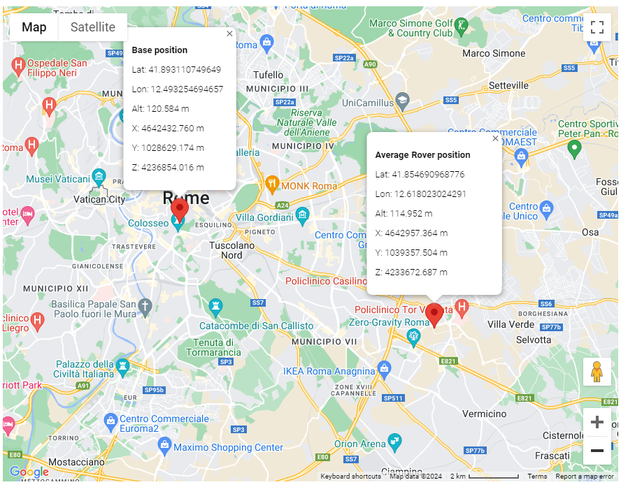
Interactive Map shows base and average rover position.

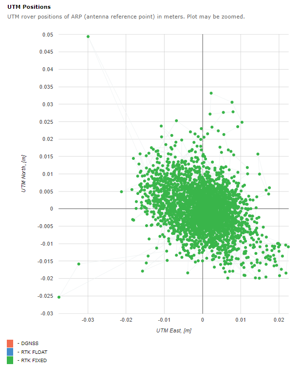
Horizontal positions (UTM) are showed on the next interactive plot. Average is substracted.
Absolute coordinates as well as baseline components may be found in GGA / CSV files below.

Plot may be zoomed. Select the area of interests by pressed left mouse button. Right mouse button click returns original zoom.

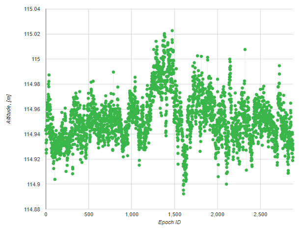
Next plot presents Geodetic altitude. May be zoomed as well.

Finally, reckoned positions (epoch-by-epoch) are presented in CSV text form and NMEA GGA message for further analysis and use.

CSV file include TAB separated columns. Columns description is presented below.
# Column Name       Description
#  0      Epoch_ID   Epoch identificator
#  1      Date       GPS Time Date, YMD format
#  2      Time_hms   GPS Time (hms) within day
#  3      Time_ms    GPS Time [ms] within day
#  4      POS_TYPE   Position Type (4 - FIXED, 5 - FLOAT)
#  5      SV_USED    Number of SVs used in RTK solution
#  6      BL_X       X-component of Base-Rover ARP baseline, m
#  7      BL_Y       Y-component
#  8      BL_Z       Z-component
#  9      X          X-coordinate of rover ARP, m
# 10      Y          Y-coordinate
# 11      Z          Z-coordinate
# 12      LAT        Geodetic Latitude of rover ARP, deg
# 13      LON        Longitude, deg
# 14      ALT        Altitude, m
# 15      PDOP       Position DOP
|