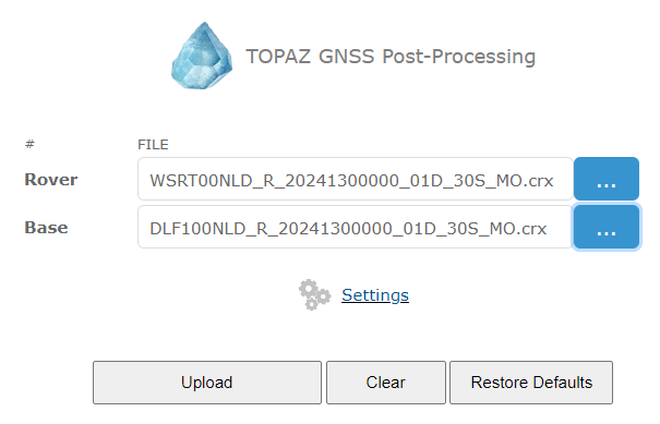
Let's process these files by TOPAZ. Un-gzip downloaded measurements from WSRT and DLF1 stations.
There should be available two files in Compact RINEX format (Hatanaka compressed):
DLF100NLD_R_20241300000_01D_30S_MO.crx
WSRT00NLD_R_20241300000_01D_30S_MO.crx
There is no need to convert CRX to RINEX, TOPAZ may process CRX directly.
Open TOPAZ online PPK processing.
Lets' agreed DLF1 station will be known base station while WSRT - "unknown" rover. Select CRX files w/ measurements.

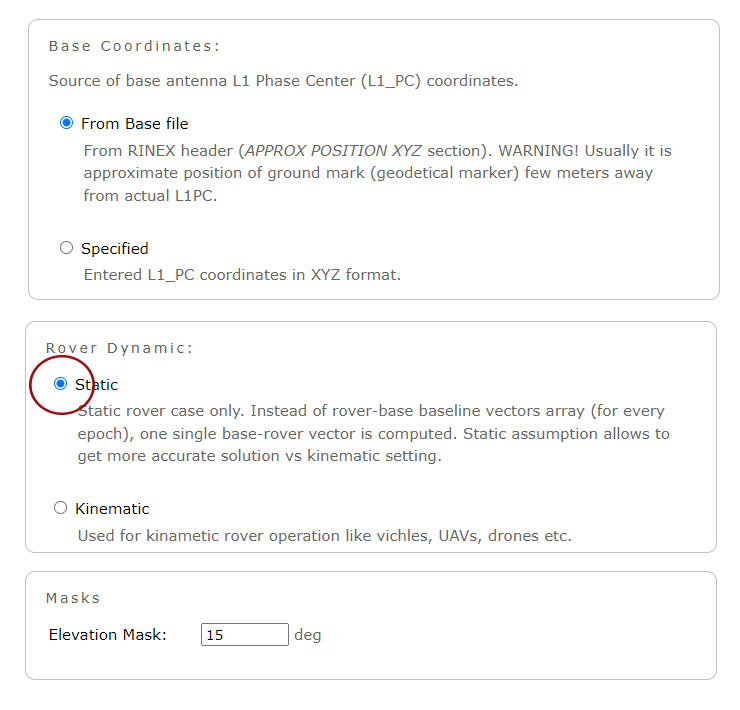
Set up static processing in Settings section.
Base coordnates may be kept as is (i.e. aproximate from RINEX) since first of all we're interested in baseline components computed by TOPAZ.
Later we will get reference coordinates of DLF1 station and simply add TOPAZ-computed base-rover baseline components in order to get rover position estimation.

Finally, press UPLOAD button. Processing will take some time, please wait. Once processing is completed,
one may check information about processed files, antennas, its PCO, input settings and results of PPK computation in form of base-rover
baseline components (highlighted in green below).
Input files | File | Name | Size | | Rover | WSRT00NLD_R_20241300000_01D_30S_MO.crx | 10.411 MB (10916602 bytes) | | Base | DLF100NLD_R_20241300000_01D_30S_MO.crx | 8.922 MB (9355629 bytes) |
General Info | WSRT00NLD_R_20241300000_01D_30S_MO.crx | DLF100NLD_R_20241300000_01D_30S_MO.crx | | File Size | 10.411 MB (10916602 bytes) | 8.922 MB (9355629 bytes) | | Input decoder | AUTO | AUTO | | Used decoder | RINEX | RINEX | | RINEX version | 3.05
Hatanaka Compressed (CRX) | 3.04
Hatanaka Compressed (CRX) | | Epochs | | Rate | 30 sec | 30 sec | | Total | 2880 | 2880 | | Time issues | 0 (0.000% ) | 0 (0.000% ) | | Missed | 0 (0.000% ) | 0 (0.000% ) | | Duration | 24 hours 0 min | 24 hours 0 min | | Time Start | Date: 2024.05.09
Time: 00:00:0.00
DOY: 130
Week: 2313
| Date: 2024.05.09
Time: 00:00:0.00
DOY: 130
Week: 2313
| | Time Stop | Date: 2024.05.09
Time: 23:59:30.00
DOY: 130
Week: 2313
| Date: 2024.05.09
Time: 23:59:30.00
DOY: 130
Week: 2313
| | Marker Name | WSRT | DLF1 | | Marker Number | 13506M005 | 13502M009 | | Receiver Model | SEPT POLARX5 | TRIMBLE ALLOY | | Receiver FW | 5.5.0 | 6.20 | | Receiver ID | 3024778 | 6235R40294 | | Antenna ID | 726840 | 10030006 | | Antenna Type | LEIAR25.R4 LEIT | LEIAR25.R3 LEIT | Antenna Delta, [m] Height / East / North | 0.375400
0.000000
0.000000
| | Antenna L1 PCO, [mm] North / East / Up | 0.800000
0.700000
159.100000
| 0.400000
0.100000
161.700000
|
Post-Processing Settings | Setting | Value | | Base Coordinates Source | From file | | Used Base Coordinates (L1_PC) (Antenna L1 Phase Center) | X: 3924698.1156
Y: 301124.8036
Z: 5001904.9952
| | Rover Dynamic | STATIC | | Elevation mask, deg | 15 |
TOPAZ STATIC Processing Results | Detaild information about static base-rover vector processing. |
| Parameter | Value | | Processing | STATIC | | Measurements type | Wide-Lane | | FIX type | FIXED | | Ephemeris used | SP3 (Precise) |
| BaseLine Components, [m] | dX: -95961.7755
dY: 142179.9426
dZ: 62979.8029
| | BaseLine Length, [m] | 182730.0030 | | RMS of Baseline estimation, [m] | 0.0642 | | Rover Antenna L1_PC Coordinates, [m] (Base antenna L1_PC coordinates + baseline components) | X: 3828736.3401
Y: 443304.7462
Z: 5064884.7981
|
It is important to ensure precise orbits and clocks (SP3) are used in PPK processing instead of broadcast Ephemeris. SP3 is vital for accurate processing of long baselines.
The best accuracy may be achieved if FINAL SP3 product is used. It is available w/ delay about 1 week.
Below are dX,dY,dZ components of baseline between base and rover antennas (L1 Phase Center):
     dX, [m]: -95961,7755
(A)  dY, [m]: 142179,9426
     dZ, [m]:  62979,8029
Let's add these baseline components to a priory known DLF1 station coordinates.
Reference coordinates computed by
Bernese GNSS Software by CODE
(Center for Orbit Determination in Europe) for 09-May-2024 may be found
here.
CRD file by CODE provides computed coordinates tagged to geodetical marker point (geodetic reference monument). These coordinates are:
     X, [m]: 3924697.57159
(B)  Y, [m]:  301125.34545
     Z, [m]: 5001905.37891
We need to convert these coords to L1_PC. First, let's take into account distance between marker and Antenna Reference Point (ARP).
RINEX file section [ANTENNA: DELTA H/E/N] is filled by zeros so marker position is equal to ARP. Next, we
need to convert ARP position to L1_PC using Antenna Phase Center Offsets (PCO).
LEIAR25.R3 LEIT antenna (installed on DLF1 station) PCO are the following:
      North:   0.4 mm
(C)   East:    0.1 mm
      Up:    161.7 mm
North and East components may be neglected (sub-millimeter). Up component is to be added to ARP Height being converted to meters (LLA format). Just in case, one may use
MEONMAP service for coordinates transformations.
      X, [m]: 3924697.57159        Lat, [deg]: 51.986021742451705
(D)   Y, [m]:  301125.34545   =>   Lon, [deg]: 4.387465412205929
      Z, [m]: 5001905.37891        Alt,   [m]: 75.819 + 0.1617 = 75.9807
Finally, DLF1 L1_PC coordinates (converted back to XYZ format) are:
      X, [m]: 3924697.6711
(E)   Y, [m]:  301125.3531
      Z, [m]: 5001905.5065
Well, next we'll add baseline components computed by TOPAZ to DLF1 L1_PC coordinates. What in turn will give us "unknown" rover WSRT coordinates of antenna L1_PC.
      X, [m]: 3924697,6711 -  95961,7755 = 3828735,8956
(F)   Y, [m]:  301125,3531 + 142179,9426 =  443305,2957
      Z, [m]: 5001905,5065 +  62979,8029 = 5064885,3094
|